The Michigan Democratic Party’s decline over the past eight years, losing support in nearly every rural community in the state, can now be viewed in granular detail thanks to newly created maps that illustrate presidential election results for every voting precinct in the nation.
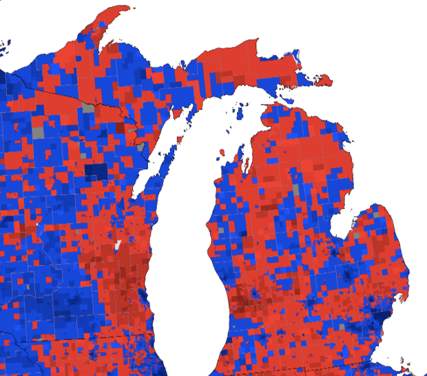
The three maps show that in 2008, the Democrats (in blue) were winning in precincts along the Lake Michigan side of the state all the way from the Leelanau peninsula down to Allegan County, south of Holland. About half of the U.P. was blue, and a long swath of territory directly north of Bay City was also Democratic. Republicans (in red) were dominant in few areas.
In 2012, despite Democratic President Barack Obama’s win over Republican Mitt Romney, the blue territory had declined, particularly in northern Michigan. Two years earlier, the GOP had won elections for governor, secretary of state and attorney general.
Now, nearly the entire 2016 election map is red except for scattered specks of blue. Those Democratic areas are almost exclusively the heavily populated urban areas of the state – Detroit, Flint, Saginaw, Lansing, Grand Rapids, Kalamazoo and the inner ring of the Detroit suburbs.
Poke around on the interactive versions of these three maps and you will see the transformation from 2008 to 2012 to 2016 come to life as the red blooms and the blue recedes.
The GOP controls the state’s executive branch and supreme court, the Legislature, the Michigan congressional delegation and, for the first time in 28 years, the Republicans carried the state in the race for the White House with Donald Trump’s narrow win in November.
The Democratic Party can’t turn back the clock but, in a political sense, that’s what they must do if they want to avoid becoming a permanent minority party in Michigan.
According to City Lab, the unprecedented maps are the creation of amateur cartographer Ryne Rhola, a Ph.D. student in economics at Washington State University.
The deeper the color red, such as in the Plains states, or the color blue, as seen along the California coast, the larger the margin in November for Trump or Hillary Clinton, respectively.
Bridge Magazine has created its own precinct map for the Michigan 2016 election, which can be viewed here.
And here’s a closer look at that 2008 map just to give readers a better idea of how many blue precincts existed just eight years ago:
Recent Posts:
 Michigan companies can’t fill jobs because too…
- Warren ranked the most ‘white trash’ city in Michigan
- Michigan avoids being Foxconned – Snyder bailed out…
- The recession recovery: Michigan No. 1 while 35…
- Islamophobic SH candidate calls on Michigan Tea…
- Michigan counties face a heavy hurt under…
- Michigan Obamacare rate increases could average 28 percent
- Website says 80% of Michigan’s best elementary…