
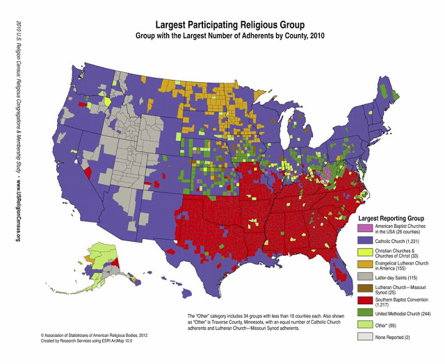

This map of the U.S. shows the majority religious
denomination in each county. The ties between geography and religion are rather
stunning, particularly in the Old South.
denomination in each county. The ties between geography and religion are rather
stunning, particularly in the Old South.
(If you want a larger, clearer version, click here.)
I realize this snapshot of the nation relies strictly on
the majority in each county, with no ambiguities or proportions, but the sharp
divides are startling.
the majority in each county, with no ambiguities or proportions, but the sharp
divides are startling.
The line that separates Baptist north Texas from Catholic
south Texas is stark, no doubt an indication of where many Hispanic immigrants –
legal or otherwise – settled. And the way that the Baptist counties stop right
at state boundaries (Oklahoma, Missouri and Kentucky) is rather bizarre – or is it the
unending throwback to the divisions between North and South that extend to the old “border” states?
I was also quite surprised at how common Catholicism is
in the west, including nearly all of California.
in the west, including nearly all of California.
One more thing: Anyone know what religion would be
dominant in the three Michigan counties that are labeled “Other?”
dominant in the three Michigan counties that are labeled “Other?”
The map was created by the Association of Statisticians of American Religious bodies and it was posted online at patheos.com.
Eaton County–South Central MI–Assemblies of God: http://www.thearda.com/rcms2010/r/c/26/rcms2010_26045_county_name_2010.asp
Ottawa–Christian Reformed of North America and the Reformed Church of America. http://www.thearda.com/rcms2010/r/c/26/rcms2010_26139_county_name_2010.asp
Missaukee Christian Reformed of North America: http://www.thearda.com/rcms2010/r/c/26/rcms2010_26113_county_name_2010.asp
I find the data interesting, thank you for sharing. But you use words such as "divide" or "stark" that have almost a negative tone. Why? Do you think its negative that there is a variety of different kinds of denominations almost comparable to dialects of language? If you think its negative, why?