This is an excerpt from a story I wrote this week for Bridge Magazine.
By Chad Selweski
The Enbridge Line 5 pipeline that runs under the Straits of Mackinac has been the focus of government studies, public hearings and media reports, all raising concern about the environmental threat posed to Michigan if the aging oil line ruptures.
But far more quietly, officials in coastal towns from Port Huron through Detroit have been raising alarms for more than decade about a petrochemical complex in Sarnia, Ontario, with the discomfiting name of Chemical Valley.
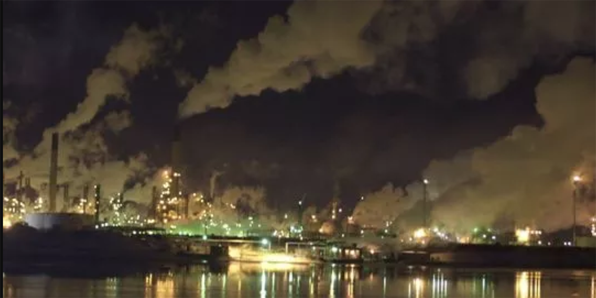
The 15-square-mile complex holds roughly 60 chemical and oil factories. At night, its smokestacks cast a dystopian glow over Sarnia and across the St. Clair River to Port Huron. Government agencies in the U.S. and Canada have recorded hundreds of spills over more than a decade involving toxic chemicals, including those that cause cancer, into the river. In several cases, downstream communities did not receive notice for hours, if at all, as chemicals flowed past Marine City, into Lake St. Clair and the Detroit River, which serve millions of southeast Michigan residents with drinking water.
“Everybody in Michigan can relate to Mackinac, but not everybody knows about, for example, Marine City,” said Macomb County Public Works Commissioner Candice Miller, the former congresswomen. Miller says the perils posed by Chemical Valley are “an equal problem due to the population in the area and the sources of public water.”
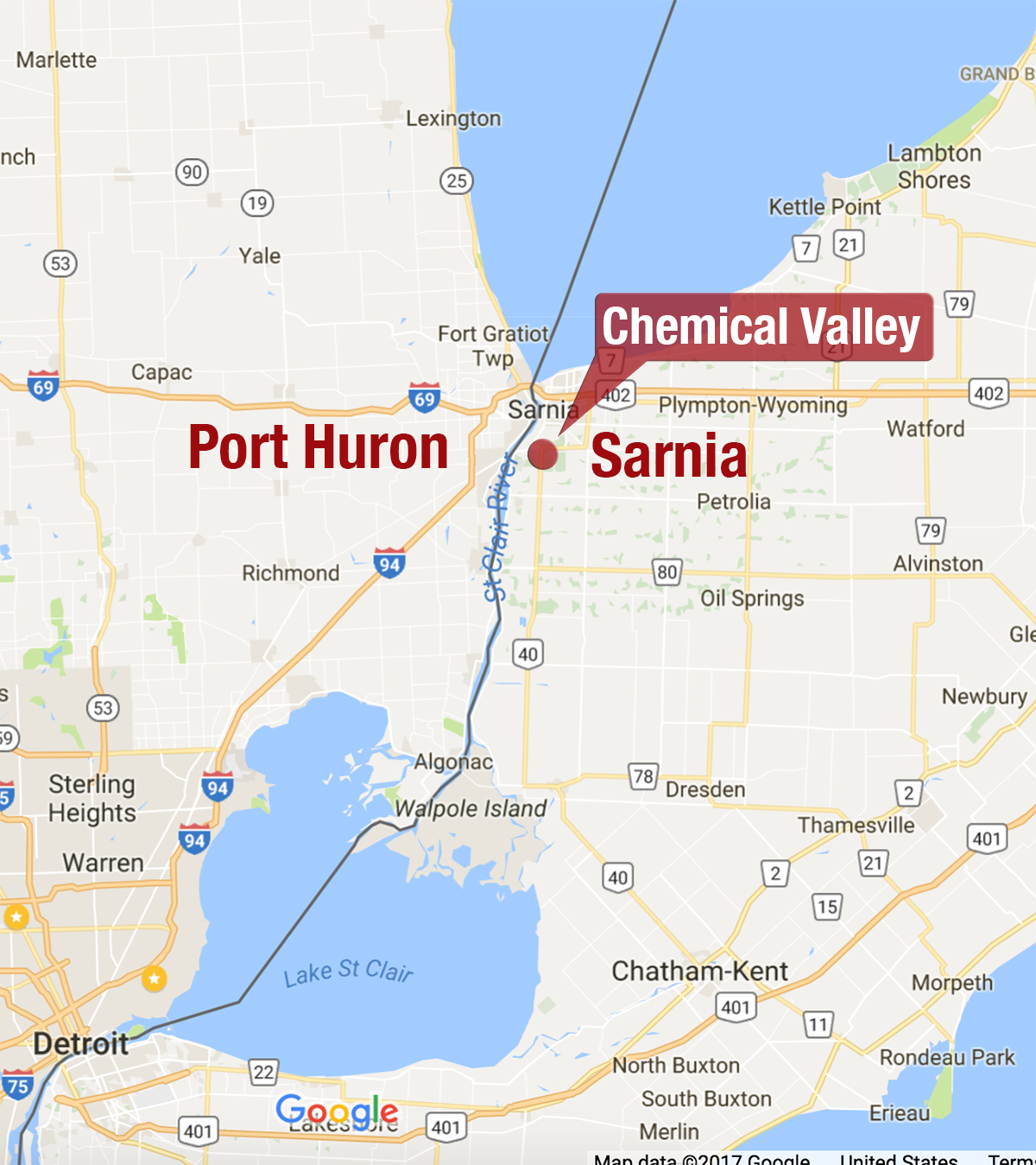 The St. Clair River connects Lake Huron to Lake St. Clair. The river contains roughly 40 pipelines, carrying all manner of oil, natural gas and hazardous materials. Indeed, the river is the end point for Enbridge’s Line 5, the Mackinac pipeline. And just south of Port Huron is a crossing by Enbridge Line 6B, the line that ruptured in 2010 near Kalamazoo, creating the biggest inland oil spill in U.S. history.
Overlooking the river is Chemical Valley, one of the largest petrochemical industry sites in North America. Forty percent of Canada’s petrochemical industry is packed into the sprawling complex, with chemical plants and oil refineries running 24/7. A 2011 report by the World Health Organization found the area had Canada’s worst air quality.
MORE COVERAGE: Toxic chemical spill? Wait for our fax
Chemical Valley produces plastics, rubber, fertilizers, asphalt, gasoline and diesel fuel, and is said to provide, directly or indirectly, an estimated 50,000 jobs. Its manufacturing process has become safer, the industries say, particularly with the reduction of benzene discharges. A toxic solvent used in the manufacturing process, benzene, has been linked to various blood cancers.
Yet, despite those gains, the Toronto Star reports that Sarnia refineries release three to 10 times the annual limit of benzene under the tougher standards put into place by Ontario.
The Sarnia Lambton Environmental Association, an industry group that represents 20 companies in Chemical Valley, dismisses the idea that factory discharges can be linked to public health concerns. The firms include some of the biggest names in the industry: Sunoco, Shell, DuPont, Imperial Oil, NOVA Chemicals, Suncor Energy and Enbridge.
“As our last report shows, the trends are very positive,” said Dean Edwardson, the association’s manager, of its 2015 report. “Our companies have strived and made progress. And the St. Clair River is in much better shape compared to 20 years ago.”
Downstream from Chemical Valley are 14 Michigan water intakes, which withdraw water for treatment plants along the St. Clair River, Lake St. Clair and the Detroit River, which provide tap water to 3.5 million people in the region.
Because the St. Clair River has such a strong current, a significant spill of hazardous materials in Sarnia could enter downstream intake pipes before authorities are even warned of the danger.
A 2014 report by the Great Lakes Environmental Research Laboratory concluded that the amount of time it takes for a Sarnia spill to reach water intakes on the U.S. side “can be on the order of minutes.”
Continue reading here.
Photo: Port Huron Times Herald
Map: Bridge Magazine
Recent Posts:
 Website says 80% of Michigan’s best elementary…
- Snyder signs bill increasing role of ‘dark money’ in…
- Michigan ranks third in bills aimed at protecting…
- Russians could have swayed Michigan election for…
- A NAFTA collapse could hurt Michigan, auto industry the most
- Kid Rock, Clinton and the clowns who protest
- Langton, Rocky and a McCotter return? Trott…
- Believe it or not, jobs and taxes are wrong messages…